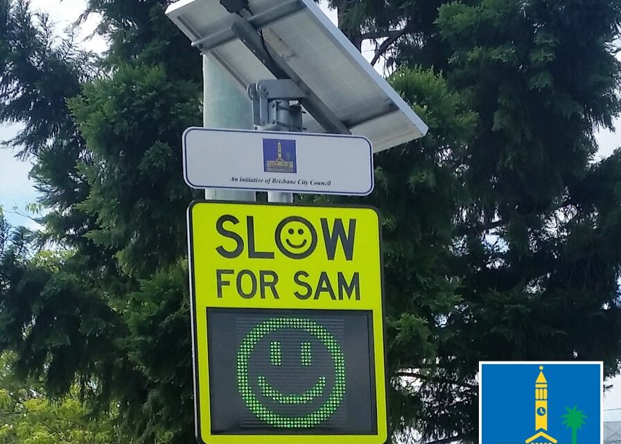
Safety around Brisbane schools will be improved with 28 new Speed Awareness Monitors (SAM’s) to be installed over the next few weeks by the Schrinner Council.
Lord Mayor Adrian Schrinner said the additional SAM signs were on top of the 30 that had been permanently placed within school zones since January as part of a $725,000 initiative.
“The SAM signs are a friendly and effective way to reminder to motorists to watch their speed when travelling through school zones,” Cr Schrinner said.
“On average, motorists have reduced their speed by more than eight kilometres per hour across all SAM sites since the program began in November 2013.
“There are currently 250 SAM’s in place across the city.”
Cr Schrinner said 13 school zones would also be targeted for enforcement action during Term 2 to stop illegal parking that is putting children in danger.
“The school enforcement list is created from the school zone parking complaints received throughout Term 1,” he said.
“A total of 190 infringements and 37 warning notices were issued in Term 1 as part of our focus on safety awareness with motorists stopping in no-stopping zones the most frequent offence.
“Every term, we implement parking enforcement strategies across schools where there has been an increase in complaints or non-compliance reported.
“This encourages drivers to do the right thing as they drop off or pick up children at these busy times during the day.
“I encourage residents to take extra care as they travel through our school zones to ensure we keep our children safe.”
New SAM site locations:
|
Suburb |
Road Name |
Street Number/ Feature |
Speed Limit |
|
Bracken Ridge |
Phillips Street |
#91 – 1m east of driveway to St Joseph’s College |
50 |
|
Forest Lake |
Wadeville Street |
Adj 60/62 Invergarry Cct |
60 |
|
Newstead |
Doggett Street |
#16 |
60 |
|
Fortitude Valley |
Robertson St |
#168 – 7m north of driveway to #128 |
50 |
|
Wakerley |
Brook Street |
Adj #5 Macquarie St |
40 |
|
East Brisbane |
Longlands St |
#53 |
50 |
|
Coorparoo |
Beresford Terrace |
#30 |
50 |
|
Deagon |
Beaconsfield Terrace |
6m south of driveway of #348 |
60 |
|
Murarrie |
Murarrie Road |
Between #61/#65 |
60 |
|
Newmarket |
Edmondstone Street |
#158 |
40 |
|
Doolandella |
Crossacres Street |
#73 – 11m west of ELP32717 |
60 |
|
Clayfield |
London Rd |
#32 |
50 |
|
Holland Park |
Victor St |
#89 |
50 |
|
Darra |
Darra Avenue |
#83 |
50 |
|
Upper Mount Gravatt |
Tryon Street |
#59 |
50 |
|
Grange |
Chermside Street |
#14 |
50 |
|
Everton Park |
Soames St |
12 |
50 |
|
Bridgeman downs |
Saturn Crescent |
Between #163/#165 |
50 |
|
Moorooka |
Hamilton Rd |
#125 |
50 |
|
Hawthorne |
Lindsay Street |
#89 – 1m west of boundary 89/87 |
50 |
|
Northgate |
Gympie Street |
#103 |
50 |
|
Bardon |
Chiswick Road |
#32 |
60 |
|
Chapel Hill |
Fleming Road |
Adj #4 Lomandra Place |
60 |
|
Yeronga |
Cansdale Street |
Adjacent football club |
50 |
|
West End |
Vulture Street |
#125 |
60 |
|
Keperra |
Gilston Street |
#23 |
50 |
|
Toowong |
Broseley Road |
#36 |
50 |
|
Wynnum |
Plaza Street |
Opp #44 |
50 |
School Zone Enforcement targeted schools:
|
School Zone |
Street |
Suburb |
|
Aspley State School |
Maundrell Terrace |
ASPLEY |
|
Craigslea State High School |
685 Hamilton Road |
CHERMSIDE WEST |
|
McDowall State School |
1018 Rode Road |
MCDOWALL |
|
Pallara State School |
39 Ritchie Road |
PALLARA |
|
Mansfield State High School |
Corner Broadwater & Ham Road |
MANSFIELD |
|
Mansfield State School |
174 Ham Road |
MANSFIELD |
|
Marshall Road State School |
Kurts Street |
HOLLAND PARK WEST |
|
Our Lady of Lourdes Primary School (Sunnybank) |
Shearwin Street |
SUNNYBANK |
|
Somerville House (South Brisbane) |
17 Graham Street |
SOUTH BRISBANE |
|
Bulimba State School |
Oxford Street |
BULIMBA |
|
Cannon Hill Anglican College |
Cnr Junction and Krupp Roads |
CANNON HILL |
|
Forest Lake State School |
Kauri Place |
FOREST LAKE |
|
Rainworth State School |
185 Boundary Road |
BARDON |

